
Chile offers an incredible variety of landscapes, and in our opinion, they are best explored on foot. During nearly a month of traveling through the country, we’ve put together a selection of our favorite outdoor experiences along the way. In this guide, we share what we believe are the best hikes in Chile, from the wild peaks of Patagonia in the south to the surreal desert landscapes of the Atacama in the far north. We’ve also included practical tips to help you plan your own unforgettable hiking adventure across this remarkable country.
This guide is ideal for independent hikers looking for day hikes across Chile, from easy scenic walks to demanding alpine routes.
Introduction
Quick Facts
- Best for: diverse landscapes: deserts, volcanoes, glaciers, forests, mountains, coastal trails
- Where to hike: National parks and reserves across the country, from the Atacama Desert to Patagonia
- Main highlights: Dramatic scenery, wildlife, pristine nature, and world-class trekking routes
- Getting around: Rental car, buses, organized transfers, or guided tours depending on region
- When to visit: Year-round: best season varies by region (Patagonia: Oct-Apr, North: Mar-Nov)
- Entrance fees: Most parks charge a fee, often payable online in advance
- Connectivity: Mobile signal is limited or nonexistent in many hiking areas
Chile offers some of the most varied and spectacular hiking landscapes in the world, suitable for both casual and experienced trekkers.
This post contains affiliate links. If you make a purchase or booking through these links, we earn a small commission at no extra cost to you. This supports our work and allows us to keep offering free content here on the blog.
Best Hikes in Chile: About This Guide
Chile is a dream destination for hikers. Stretching over 4,000 kilometers from north to south, the country offers an extraordinary variety of landscapes: otherworldly deserts, ancient forests, turquoise lakes, snow-capped volcanoes, and the iconic peaks of Patagonia.

We began our journey in southern Chile, spending tree unforgettable days exploring the wild beauty of Torres del Paine National Park. From there, we slowly traveled north along the legendary Carretera Austral, took a ferry to Chiloé Island, and then continued through the stunning landscapes of Chile’s Lake District. After a short (non-hiking) stop in the capital, Santiago, we made our way further north to the surreal desert scenery of the Atacama.
Throughout the trip, the landscapes and the climate changed constantly. In Patagonia’s summer (!), we found ourselves bundled up in windproof jackets, beanies, and scarves, only to gradually swap them for lighter clothing as we moved north. We started this journey in February and found this route particularly well suited for that time of year. That said, the itinerary can just as easily be done in reverse (north to south) or focused on a single region, depending on how much time you have.

We completed most of the trip using public transportation, which worked surprisingly well in many areas. Long-distance buses run frequently between major cities and are very comfortable, with generous legroom and semi-reclining seats. In a few places, such as Villa Cerro Castillo and parts of the Lake District, we rented a car for greater flexibility and easier access to trailheads. Traveling by bus along the Carretera Austral required a bit more planning, but it also provided a deeper glimpse into local life and culture.
All the hikes featured below were done independently, without guides, and we genuinely loved every single one. Each trail offers a unique landscape, atmosphere, and level of challenge: no two experiences felt alike. Taken together, they provide a rich and unforgettable picture of Chile’s remarkable natural diversity.
Overview of Our Favorite Hikes in Chile
| Hike | Location | Distance & Elevation | Difficulty | Highlights |
|---|---|---|---|---|
| Valle de la Luna Trails | Atacama Desert, near San Pedro | Varies (several short trails) | Easy-Moderate (heat) |
Surreal desert landscapes Easy access to viewpoints Incredible sunsets |
| Lagos Chico, Verde & Toro | Huerquehue National Park, Lake District | ~13 km out-and-back, 783m | Moderate |
Ancient araucaria forests Scenic alpine lakes Volcano views |
| Sierra Nevada Trail | Conguillío National Park | ~12 km out-and-back, 598m | Moderate |
Views of Llaima Volcano Araucaria forests Condor spotting possible |
| Mirador Sur – Las Dunas – Río Cipresal | Chiloé National Park, Chiloé Island | ~6 km loop, 89m | Easy |
Coastal viewpoints Temperate rainforest, dunes, rivers Native wildlife |
| Chaitén Volcano Hike | Pumalín Douglas Tompkins National Park | ~5 km out-and-back, 621m | Moderate-Hard |
Panoramic volcano & lake views History of 2008 eruption Free entry to park |
| Laguna Cerro Castillo | Cerro Castillo National Park | ~13.5 km out-and-back, 1,125m | Hard |
Turquoise alpine lake Dramatic mountain scenery Remote and less crowded |
| Cuernos Lookout | Torres del Paine National Park | ~6.5 km out-and-back, 201m | Easy |
Panoramic views of Los Cuernos Salto Grande waterfall Easy with minimal effort |
| Base Torres Hike | Torres del Paine National Park | ~20.5 km out-and-back, 1,023m | Hard |
Iconic three granite towers Turquoise glacial lake Varied terrain with forests, rivers, valleys, and ridges |
Best Hikes in Chile
Valle de la Luna Trails: Hiking in an Otherworldly Desert
Location: Valle de la Luna, Atacama Desert
Distance: Varies (several short trails)
Elevation: Varies
Difficulty: easy-moderate (mostly because of the heat)
Located just outside San Pedro de Atacama, Valle de la Luna, the Valley of the Moon, is one of the most surreal landscapes in Chile.
Instead of forests or glaciers, the trails here lead through vast fields of salt, sand dunes, and eroded rock formations shaped by millions of years of wind and drought. The landscape is so unusual that it genuinely feels like walking on another planet.
Several short hiking paths lead to viewpoints overlooking the desert’s dramatic ridges and dunes. At sunset, the colors of the valley shift from pale beige to deep orange and red, making it one of the most unforgettable moments in the Atacama. And did you know that the skies here are among the best in the world for stargazing?
Highlights:
- One of the most unique landscapes in Chile
- Easy trails accessible for most visitors
- Incredible sunset views over the desert formations
Entrance fee: Buy tickets here
Accommodation tip: Hotel Casa Algarrobo
Lagos Chico, Verde & Toro: Hiking in Chile’s Lake District
Location: Huerquehue National Park (near Pucón)
Distance: ~13 km out-and-back
Elevation: 783m
Difficulty: moderate
Find the hike on AllTrails
The Los Lagos trail in Huerquehue National Park is, in our opinion, one of the most beautiful hikes in Chile’s Lake District. The first part of the trail climbs gradually through ancient forests of araucaria trees, one of the oldest tree species on the planet and an iconic symbol of Chile. Even on sunny days, the path remains pleasantly shaded, with soft light filtering through the forest canopy.
The elevation gain is moderate, but after rainy days the trail can become muddy and slippery, so trekking poles can definitely be helpful! Along the way, you may spot curious lizards and occasionally catch glimpses of the surrounding lakes and mountains. Eventually, the trail reaches a series of stunning mountain lakes, including Lago Chico, Lago Verde, and Lago Toro. On warm sunny days, it’s even possible to take a refreshing swim. The peaceful atmosphere makes this a perfect spot to relax and enjoy the scenery. Two waterfalls can also be visited along the route. However, park rangers generally recommend visiting them on the way down, so you can be sure you’ll have enough time to complete the hike.

Highlights:
- Unique forests of ancient araucaria (monkey puzzle) trees
- Several scenic alpine lakes along the trail
- Views toward the volcanoes surrounding the region
Entrance fee: Buy tickets here
Accommodation tip: Hotel y Termas Huife (double room) or Amanecer de Caburgua (2-bedroom apartment)
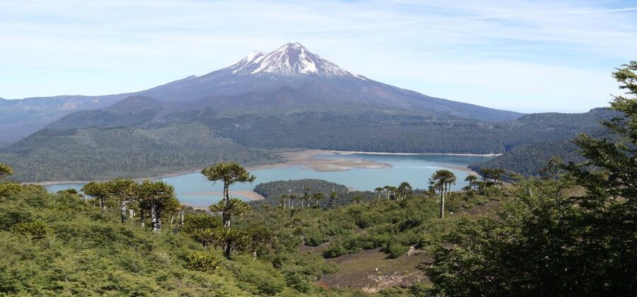
Sierra Nevada Trail: Volcano Views in Conguillío National Park
Location: Conguillío National Park (near Melipeuco)
Distance: ~12 km out-and-back
Elevation: 598m
Difficulty: moderate
Find the hike on AllTrails
The Sierra Nevada trail in Conguillío National Park truly has it all: peaceful forest paths, stunning lake views, volcanic landscapes, and a wonderful variety of scenery along the way. Even the drive to the parking lot is scenic, passing through forests where beautiful rays of light filter through the trees, with occasional glimpses of the surrounding volcanic landscape. The route climbs steadily through shady forests filled with the iconic araucaria trees we had already encountered in Huerquehue National Park. Along the way, several viewpoints invite you to pause and admire the views over Lake Conguillío. After the first viewpoint, the trail becomes more exposed to the sun and eventually reaches a plateau, where you’re rewarded with magnificent views of Llaima Volcano, the surrounding forests, and, with a bit of luck, you can spot condors. From here on, the rest of the trail is relatively flat until the final viewpoint, which once again offers a gorgeous view of the snow-capped volcano, the lake, and the surrounding green forest.

Highlights:
- Spectacular panoramic views of Llaima Volcano and Lake Conguillío
- Unique combination of ancient araucaria forests and unique volcanic landscapes
- Several viewpoints along the trail, with the chance to spot condors above the valley
Entrance fee: Buy tickets here
Accommodation tip: CasaVerde Hostal Ecologico
Mirador Sur – Mirador Las Dunas – Río Cipresal: Hiking Through the Mystical Forests of Isla Chiloé
Location: Chiloé National Park, Chiloé Island
Distance: ~6 km loop
Elevation: 89m
Difficulty: easy
Find the hike on AllTrails
Located on the wild Pacific coast of Chiloé Island, the Mirador Sur – Mirador Las Dunas – Río Cipresal trail in Chiloé National Park offers a completely different hiking experience compared to the mountains of Patagonia or the deserts of northern Chile.
The path winds through dense temperate rainforest, where twisted trees, thick moss, and ferns create a lush, almost mystical atmosphere. Most of the trail follows wooden boardwalks, making it easy to navigate. As you continue, the landscape gradually opens up, leading to Mirador Las Dunas, a stunning viewpoint overlooking the wild Pacific coastline, sandy dunes, and the vast ocean. Along the way, we even saw wild horses and cows, as well as falcon-like birds along the beach.
The combination of rainforest, dunes, river, and ocean makes this hike one of the most diverse and scenic experiences on Chiloé Island. Despite being relatively short, it’s a wonderful way to discover the wild and atmospheric landscapes that make Chiloé National Park so unique.

Highlights:
- Stunning coastal views from Mirador Las Dunas
- Unique mix of temperate rainforest, dunes, river, and ocean landscapes
- Opportunities to spot native wildlife, including wild horses and birds
Entrance fee: Buy tickets here
Accommodation tip: Chiloe Loft & Glamp
Chaitén Volcano Hike: Climbing One of Patagonia’s Youngest Volcanoes
Location: Chaitén Volcano (near Chaitén)
Distance: ~5 km out-and-back
Elevation: 621m
Difficulty: moderate – hard
Find the hike on AllTrails
There are many fascinating stories to be told about Chaitén and Pumalín Douglas Tompkins National Park.
In 2008, Chaitén Volcano erupted, devastating the small town of Chaitén and forcing the evacuation of around 5,000 residents. Although there were plans to relocate the town entirely, many people gradually returned. Today, Chaitén has come back to life as a small but lively hub, and one of the main gateways to Pumalín Douglas Tompkins National Park.
The park itself was created by Douglas Tompkins (founder of the Patagonia clothing company) and his wife Kristine Tompkins. It is one of the few national parks in Patagonia that can be visited free of charge. From Chaitén, the easiest way to reach the park is by organized transport (see our Carretera Austral guide for details), a rental car or even hitchhiking.
The relatively short hike up Chaitén Volcano begins in peaceful, native forest and follows a well-marked path with steps for much of the way. Although the distance is modest, we found the final section surprisingly challenging due to its steep incline and exposure to the sun. The effort however is more than worthwhile! From the summit, you’ll have a view on the crater and can enjoy the panorama of of surrounding lakes, mountains and colorful wildflowers. Depending on the season, hikers sometimes report large numbers of flies at the top, so bringing insect repellent is a good idea.

Highlights:
- Panoramic views over lakes, mountains, and dense Patagonian rainforest
- Insight into the powerful 2008 eruption that reshaped Chaitén and the surrounding landscape
- Located within the pristine wilderness of Pumalín Douglas Tompkins National Park
Entrance fee: no entrance fee
Accommodation tip: Cabañas Alelí (1-bedroom apartment) or Hostal La Minga (hotel with private beach access)
Laguna Cerro Castillo: The Perfect Day Hike
Location: Cerro Castillo National Park
Distance: ~13.5 km out-and-back
Elevation: 1,125m
Difficulty: hard
Find the hike on AllTrails
The Laguna Cerro Castillo hike was our favorite hike on the Carretera Austral!
The trail starts through forests and open slopes, gradually revealing wider views of the surrounding valleys, rivers, and rugged peaks. Around the 5-km mark, we passed a park ranger station, where the ranger checked in on hikers and pointed us to a spot where we could refill our water bottles.
The final section is the most demanding: a steep ascent over loose terrain, which on our hiking day was accompanied by strong winds. At that point, we really wished we had brought trekking poles… 😀 However, once we reached the top, any sense of effort and discomfort was instantly replaced by pure awe at what lay before us: Laguna Cerro Castillo is a bright, turquoise lake, with a background of snowy mountain peaks and hanging glaciers. The color of the water looked almost unreal, but the glacial minerals suspended in it are the reason for this intense turquoise-blue. It’s truly one of those views that makes you fall silent for a moment and simply take it all in. Since the wind remained quite strong, we took shelter behind a few rocks and enjoyed the view from there for a while. Eventually, we decided to head back down to the ranger station, where conditions were much calmer, and had our lunch while soaking in the still gorgeous views over the valley.

Highlights:
- Intensely turquoise waters of Laguna Cerro Castillo
- Gorgeous alpine scenery
- Off-the-beaten-path alternative to Torres del Paine National Park
Entrance fee: sold at the park entrance
Accommodation tip: Cabaña Caiquen
Cuernos Lookout: Little Effort, Big Scenery
Location: Torres del Paine National Park
Distance: ~6.5 km out-and-back
Elevation: 201m
Difficulty: easy
Find the hike on AllTrails
We initially chose this trail as a way to recover from the longer routes in the park, but the Cuernos Lookout hike quickly exceeded all expectations and soon became one of our favorite hikes in Chile.
The trail begins near Refugio Pudeto and almost immediately offers beautiful views of Lake Pehoé. Shortly afterward, you’ll reach the powerful Salto Grande waterfall, one of the most impressive cascades in Torres del Paine National Park.
From there, the path continues across open terrain with uninterrupted views of the breathtaking Los Cuernos (“The Horns”) mountain range. Their distinctive layered rock formations rise sharply above the vivid blue waters of Lake Nordenskjöld, creating one of Patagonia’s most striking landscapes. If you’re looking for a shorter trail with spectacular scenery, this is one of the best options – but honestly, it shouldn’t be skipped even if you have more time.

Highlights:
- Panoramic views of the dramatic Los Cuernos peaks rising above Lake Nordenskjöld
- Close-up views of the powerful Salto Grande waterfall
- Easy trail with exceptional scenery and minimal effort
Entrance fee: Buy tickets here (multi-day passes available)
Accommodation tip: for example Yellow Plum Camp Pehoé; see our article for detailed info about accommodation inside and around the park.
Base Torres Hike: Patagonia’s Most Iconic View
Location: Torres del Paine National Park
Distance: ~20.5 km out-and-back
Elevation: 1,023m
Difficulty: hard
Find the hike on AllTrails
Widely considered the most famous hike in Torres del Paine National Park, the trail to Mirador Base Las Torres delivers everything you would expect from a classic Patagonian trek: varied terrain, dramatic scenery, river crossings, and a demanding final ascent rewarded by one of the most iconic views in South America.
The route begins with a steady climb through open landscapes and forests, gradually revealing stunning views over valleys and lakes. Wind conditions change constantly: some sections are sheltered, while others are completely exposed, including the aptly named “Windy Pass.”
Around kilometer 6, you’ll reach Chileno Campsite, a convenient spot to rest, refill water, or grab a snack. From there, the trail continues with moderate ups and downs before the final push: a steep, relentless climb over rocky terrain to the viewpoint. At the top, the breathtaking panorama of the three iconic granite towers rising above a turquoise glacial lake finally unfolds; a sight that truly makes every step feel worthwhile.

Highlights:
- One of the most famous viewpoints in Torres del Paine National Park
- The iconic three granite towers rising above a turquoise glacial lake
- Varied trail featuring forests, rivers, valleys and exposed alpine terrain
Entrance fee: Buy tickets here (multi-day passes available)
Accommodation tip: for example Yellow Plum Camp Pehoé; see our article for detailed info about accommodation inside and around the park.
Discover More: Hikes in Argentina
Chile and Argentina share a border of more than 5,000 kilometers. And along much of Patagonia, they also share some of the most spectacular hiking landscapes in the world. The good news is that traveling between the two countries is relatively easy, with regular bus connections linking many destinations on both sides of the Andes.
If you still have time in your itinerary, we highly recommend continuing your adventure in Argentina! The trekking capital of El Chaltén offers world-class hikes beneath the iconic peaks of the Fitz Roy Massif (you can read more in our El Chaltén guide here), while Ushuaia, the southernmost city in the world, provides access to coastal mountains, lakes, forests, and unique sub-Antarctic landscapes.

Tips for Hiking in Chile
Fast-Changing Weather
Weather conditions can shift within minutes, especially in Patagonia. Sunshine, strong winds, rain, and even snow can all occur in a single day; sometimes within the same hour. We sometimes started hikes in a T-shirt, only to be hit by icy winds at higher elevations and end up wearing a sweatshirt, jacket, scarf and beanie. Always pack layers, including a waterproof jacket (and waterproof pants if possible). Sunscreen is essential as well: even on cold or cloudy days, the sun can be surprisingly intense, especially at higher altitudes.
Water and Food
Many trails are remote and have no services, shops, or shelters along the way. Bring more water and snacks than you think you’ll need, particularly on longer routes. While some hikes offer natural water sources, such as rivers, these may not always be accessible or safe to drink untreated.
Packing List
- Cash (CLP)
- Windproof & waterproof jacket
- Warm layers (find animal-free puffers for example on Save The Duck)
- Hiking boots (waterproof recommended)
- Quick-dry clothing
- Hat, gloves & sunglasses
- Trekking poles
- Reusable water bottle
- Snacks & packed food
- Headlamp or flashlight (early starts / campsites)
- Power bank (limited charging options in refugios)
- Sunscreen & lip balm (strong UV, even in cold weather)
Entrance Fees
Most national parks and protected areas in Chile charge an entrance fee, which varies depending on the location and whether you are a Chilean resident or a foreign visitor. A notable exception is the hike up Chaitén Volcano in Pumalín Douglas Tompkins National Park, which is currently free to access. Always check official park information in advance, as prices, regulations, and opening hours can change. If a ticket is required, it’s often best to purchase it online beforehand. For example, Conguillío National Park only sells entrance tickets online. Since there is no reliable mobile signal or Wi-Fi inside the park, buying one last minute can be difficult. In contrast, Cerro Castillo National Park typically allows visitors to purchase tickets at the park entrance.
Offline Maps
Mobile coverage inside most national parks in Chile is often extremely limited or nonexistent. Don’t rely on having internet access for navigation, communication, or bookings once you’re inside the park. Because of the lack of connectivity, it’s essential to download maps and route information in advance. Apps like AllTrails are very useful for planning and navigation, just make sure to save the trails for offline use before your trip. It’s also a good idea to download an offline map of the entire area in Google Maps or MAPS.ME.
Planning Tip: For hiking across Chile, we found AllTrails to be an extremely helpful tool for planning and navigating our routes. The app provides detailed trail maps, elevation profiles, distances, and recent reviews from other hikers, making it much easier to prepare before setting out.
Fragile Ecosystems
We know that most readers of this guide are already mindful travelers, but a littler reminder never hurts 😀 Chile’s landscapes range from ancient temperate rainforests to high-altitude deserts and glacial environments, many of which are extremely fragile and highly sensitive to human impact. Stay on marked trails, pack out all your trash, avoid feeding or disturbing wildlife, and follow Leave No Trace principles to help preserve these extraordinary places for future visitors.

Best Time to Hike in Chile
Chile is an incredibly long country, stretching over 4,000 km from north to south. That’s why the best hiking season can vary depending on the region.
Northern Chile & Atacama Desert
(San Pedro de Atacama, Valle de la Luna)
Best time: March-May and September-November
The Atacama Desert can be visited year-round, but temperatures vary greatly between day and night. Summer (December-February) brings intense heat during the day and the possibility of sudden rainstorms due to the “Bolivian winter,” which can cause flash floods. Winter (June-August) offers pleasant daytime temperatures but very cold nights, sometimes dropping below freezing.
Central Chile & Lake District
(Pucón, Conguillío National Park, Huerquehue National Park)
Best time: November-April
This region offers lush forests, lakes, and volcano landscapes. Summer provides the most stable weather and easiest trail conditions. In spring and autumn, temperatures are cooler and crowds are smaller, but some trails may still have snow or mud.
Patagonia
(Torres del Paine National Park, Cerro Castillo National Park, Carretera Austral)
Best time: December-March
Patagonia has a short hiking season due to its harsh climate. Summer offers the longest daylight hours, milder temperatures, and the highest chance of accessible trails. However, this is also peak season, meaning more crowds and higher prices. Shoulder seasons (November and April) can be magical, with fewer visitors and beautiful autumn colors; but weather becomes less predictable, and snow is possible.
Chiloé & Southern Rainforests
(Chiloé National Park, Chiloé Island)
Best time: December-March
This region is known for its lush temperate rainforest and frequent rain. Summer offers the driest conditions, though showers are still common. Trails can be muddy year-round, so waterproof footwear is highly recommended.
Overall Best Months for Hiking Chile
December to March: Best for Patagonia and southern regions
October to April: Good for central Chile and the Lake District
Year-round: Northern desert regions (with seasonal considerations)
Conclusion
Chile truly surprised us with its incredible diversity. Traveling through the country from north to south, or vice versa, feels like moving across entirely different worlds, from deserts to green forests and wild Patagonian mountain peaks. Watching the landscapes, climate zones, and vegetation transform along the way is a fascinating experience in itself, and if you have the time, we wholeheartedly recommend exploring the country from end to end. That said, even shorter trips make Chile an outstanding destination. Depending on the season and your interests, each region offers something unique, and this guide will hopefully help you find the area that best suits your travel and hiking style. Whatever you choose, we’re confident you’ll be just as amazed as we were by this extraordinary country!

This guide is completely free. If it helped you plan your trip and you’d like to say thank you, you can do so here 🙂

FAQ: Hiking in Chile
What is the best region for hiking in Chile?
Chile offers excellent hiking across the entire country. Patagonia is famous for dramatic mountain scenery, the Lake District for forests and volcanoes, Chiloé for coastal landscapes, and the Atacama Desert for otherworldly terrain. The best region depends largely on the season and your preferred type of scenery.
When is the best time to hike in Chile?
The ideal time varies by region. Patagonia is best from December to March, the Lake District from November to April, and northern Chile can be visited year-round, with spring and autumn offering the most comfortable temperatures.
Do I need to pay entrance fees for national parks?
Most national parks and protected areas in Chile charge an entrance fee, often payable online in advance. Some parks only sell tickets online, while others allow purchase at the entrance. A notable exception is the Chaitén Volcano hike, which is currently free to access.
Can I hike independently in Chile?
Yes. Most day hikes in Chile are well-marked and can be completed independently without a guide. However, proper preparation, navigation tools, and awareness of weather conditions are essential, especially in remote areas.
Is it easy to get to trailheads without a car?
In many regions, yes. Long-distance buses connect major cities, and local transfers, shuttles, or tours often provide access to popular parks. However, renting a car can offer greater flexibility, especially along the Carretera Austral and in more remote areas.
How difficult are the hikes in Chile?
Chile offers trails for all levels, from short scenic walks to demanding alpine hikes with significant elevation gain. Conditions such as heat in the north or strong winds in Patagonia can increase the difficulty.
What should I pack for hiking in Chile?
Essentials include sturdy hiking shoes, layered clothing, a windproof and waterproof jacket, sun protection, plenty of water, and snacks. In Patagonia especially, weather can change rapidly, so being prepared for cold, wind, and rain is crucial.
Is mobile signal available in national parks?
Mobile coverage is often very limited or nonexistent in most hiking areas. It’s important to download offline maps and trail information in advance using apps like AllTrails, Google Maps, or MAPS.ME.
Are Chile’s hiking trails crowded?
Some famous destinations, such as Torres del Paine, can be busy during peak season. However, many other parks and regions remain relatively quiet, offering a more remote and peaceful experience.
Is Chile safe for hiking?
Chile is generally considered a safe country for hiking. The main risks are environmental, including rapidly changing weather, strong winds, heat, or remote conditions. Proper planning and preparation greatly reduce potential hazards.
Further Reading
Blog Articles
Chile:
Torres del Paine:
Other Hiking Guides:
- Valbona Pass: Hiking from Valbona to Theth (Albania)
- Tarnica and the Bieszczady Mountains: The Ultimate Hiking Guide (Poland)
- Five Polish Ponds: A Closer Look at One of Poland’s Most Popular Hikes (Poland)
Useful Resources

About the Authors
Lynn & Daniel are the vegan couple behind VanderlustJourney, combining their passion for adventure and plant-based living. They share stories and visuals of natural places, hikes, vegan discoveries, and meaningful encounters from around the world – always striving to travel with kindness.
👉 Follow us on Instagram
✉️ Contact: vanderlustjourney@outlook.com